Solar & Daylight Data
Sun Path & Solar Angles for Washington, DC
Calculated solar-noon angles and a first-pass fixed-shading worksheet for Washington, DC, using transparent solar geometry rather than an unexplained chart.
On this page
Last updated August 17, 2026 · Original calculation using latitude 38.9072° N and declinations +23.44°, 0°, and -23.44°. Formula: altitude = 90° - |latitude - declination|. Time zone: America/New_York. Verify occupied-hour positions with the NOAA Solar Calculator; values omit refraction, equation of time, terrain, obstructions, and facade azimuth.
Direct answer
Calculated solar-noon angles and a first-pass fixed-shading worksheet for Washington, DC, using transparent solar geometry rather than an unexplained chart. A key reference is latitude: 38.9072° N; check the cited source, edition, units, and applicability before using it for design, compliance, procurement, or approval. Latitude is 38.9072° N; Washington, DC. June solstice noon is 74.5°; south at solar noon. Equinox noon is 51.1°; geometric solar noon. Projection ratio = 1 / tan(solar altitude). Multiply the ratio by the vertical distance the noon shadow must cover. Use this only as a hand check before a full-year study. Read the values with the cited source, edition or observation period, units and applicability; replace illustrative inputs with current project evidence before design, procurement or approval use.
Content and cited inputs reviewed by Harth team · Published 2026-08-17 · Updated 2026-08-17.
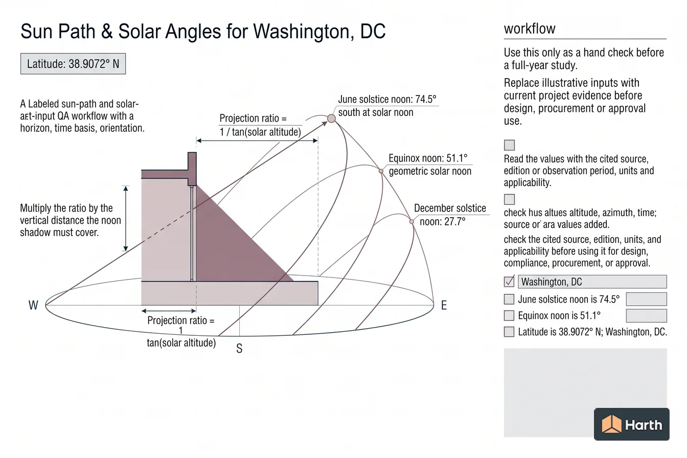
Which solar conditions control the result?
| Date | Declination | Altitude | Projection / vertical shade distance |
|---|---|---|---|
| June solstice | +23.44° | 74.53° | 0.277 |
| Equinox | 0° | 51.09° | 0.807 |
| December solstice | -23.44° | 27.65° | 1.909 |
Projection ratio = 1 / tan(solar altitude). Multiply the ratio by the vertical distance the noon shadow must cover. Use this only as a hand check before a full-year study.
Washington, DC shading record
Record facade azimuth, window head and sill, overhang height, required shaded dates and hours, coordinates (38.9072° N), time zone (America/New_York), calculation method, surrounding obstructions, reviewer and date. Compare the full model against the three noon ratios above and retain screenshots of the critical summer and shoulder-season hours. Verify hourly positions with the NOAA Solar Calculator.
Where can you explore related guidance?
- Explore all solar data guidance
- Understanding Sun-Path Diagrams
- Solar Altitude and Azimuth: Meaning, Formulas & Worked Example
- Climate Design Data Workflow for Washington, DC
Sources and method
Original calculation using latitude 38.9072° N and declinations +23.44°, 0°, and -23.44°. Formula: altitude = 90° - |latitude - declination|. Time zone: America/New_York. Verify occupied-hour positions with the NOAA Solar Calculator; values omit refraction, equation of time, terrain, obstructions, and facade azimuth.
Source links
Frequently asked questions
What is the sun angle in Washington, DC at the summer solstice?
The declination-only solar-noon altitude is approximately 74.5°. This is a transparent geometry check, not a substitute for an hourly solar-position calculation.
Related pages
- Sun Path & Solar Angles for San Francisco, CA
Sun-path design data for San Francisco, CA: solstice and equinox solar-noon altitude, shadow ratios, assumptions, and an architect-oriented shading worksheet.
- Sun Path & Solar Angles for Seattle, WA
Sun-path design data for Seattle, WA: solstice and equinox solar-noon altitude, shadow ratios, assumptions, and an architect-oriented shading worksheet.
- Sun Path & Solar Angles for Tucson, AZ
Sun-path design data for Tucson, AZ: solstice and equinox solar-noon altitude, shadow ratios, assumptions, and an architect-oriented shading worksheet.
- Sun Path: Angeles City, Philippines
Sun path for Angeles City, Philippines: solar-noon altitude 81.7° June, 74.8° equinox, 51.4° December; 11.1–12.9 h daylight; 12-month geometry table.
- Sun Path: Ashburton, New Zealand
Sun path for Ashburton, New Zealand: solar-noon altitude 22.7° June, 46.1° equinox, 69.5° December; 8.7–15.3 h daylight; 12-month geometry table.
- Sun Path: Athlone, Ireland
Sun path for Athlone, Ireland: solar-noon altitude 60.0° June, 36.6° equinox, 13.1° December; 7.2–16.8 h daylight; 12-month geometry table.