Solar & Daylight Data
Daylight & Orientation: Mandera, Kenya
How to research daylight & orientation for a specific site in Mandera — the controlling authority, source documents, and checks to run before you rely on a number.
On this page
Last updated September 2, 2026 · Location data from the [GeoNames KE dump](https://download.geonames.org/export/dump/KE.zip) (CC BY 4.0, snapshot 2026-08-31, GeoNames ID 187896). Regulatory starting point: [National Construction Authority and the applicable county government](https://www.nca.go.ke/). Figures are illustrative — verify against the current locally adopted edition for the site. Solar-method context: [NOAA Solar Calculation Details](https://gml.noaa.gov/grad/solcalc/calcdetails.html); the Harth monthly table uses a simpler declination and geometric-daylight approximation whose stated limitations must be retained. Project-date refinement reference: [NREL Solar Position Algorithm](https://midcdmz.nrel.gov/spa/).
Direct answer
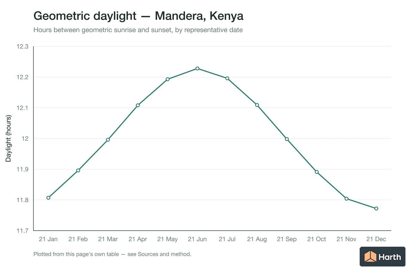
For Mandera at 3.9373, 41.8569, the declination-only solar-noon altitude is approximately 70.5° at the June solstice, 86.1° at an equinox and 62.6° at the December solstice. Refine these geometry checks with the project date, civil time, facade azimuth, terrain and local horizon. The reproducible location record is GeoNames ID 187896 in administrative area 33, at 3.9373, 41.8569; replace it with the surveyed parcel point before relying on the result. As a transparent geometry check, declination-only solar-noon altitude is about 70.5° at the June solstice, 86.1° at an equinox and 62.6° at the December solstice. Representative 21st-day geometry ranges from about 11.8 hours in December to 12.2 hours in June; this excludes atmospheric refraction, terrain and obstruction effects. The cited national authority is a discovery starting point; current local documents and a named qualified reviewer control project use of this daylight and building orientation record.
Content and cited inputs reviewed by Harth team · Published 2026-08-26 · Updated 2026-09-02.
What must be verified for Mandera?
Mandera is represented here at approximately 3.9373, 41.8569 for discovery and workflow planning. A project address, parcel, elevation, exposure, authority, and submission date must replace that city-centre reference before design use.
How should daylight and building orientation be established?
- Fix the surveyed site and local time basis.
- Select an authoritative weather source or a named solar-position algorithm.
- Record period, percentile or scenario and units.
- Test sensitivity to elevation, exposure, urban form and horizon.
- Save the source file, retrieval date and checker in the model record.
| Input | Project-specific evidence | QA question |
|---|---|---|
| Site | surveyed coordinates, elevation and horizon | Does the point represent the building? |
| Weather/solar method | named dataset, algorithm, period and time basis | Are station, time zone and units explicit? |
| Design scenario | current and future scenario agreed by the team | Is an average being mistaken for an extreme? |
| Compliance | adopted local document and edition | Was applicability confirmed with the authority? |
What are the limits of this worksheet?
This daylight-workflow page is a project-starting worksheet, not a design value or approval. The controlling authority and qualified professionals for the Mandera site remain authoritative.
Mandera monthly daylight-orientation ledger
| Representative date | Geometric daylight | Solar sunrise | Solar sunset | Sunrise hour angle | Noon bearing | Change from prior month |
|---|---|---|---|---|---|---|
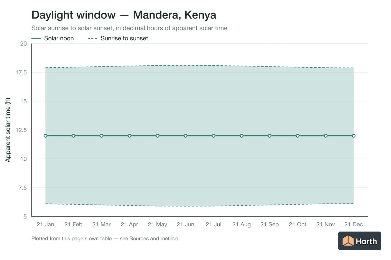
| 21 January | 11.807 h | 06.10 | 17.90 | 88.55° | 180.0° | +0.035 h |
| 21 February | 11.896 h | 06.05 | 17.95 | 89.22° | 180.0° | +0.088 h |
| 21 March | 11.996 h | 06.00 | 18.00 | 89.97° | 180.0° | +0.101 h |
| 21 April | 12.108 h | 05.95 | 18.05 | 90.81° | 0.0° | +0.111 h |
| 21 May | 12.193 h | 05.90 | 18.10 | 91.45° | 0.0° | +0.085 h |
| 21 June | 12.228 h | 05.89 | 18.11 | 91.71° | 0.0° | +0.035 h |
| 21 July | 12.196 h | 05.90 | 18.10 | 91.47° | 0.0° | -0.032 h |
| 21 August | 12.109 h | 05.95 | 18.05 | 90.82° | 0.0° | -0.087 h |
| 21 September | 11.998 h | 06.00 | 18.00 | 89.99° | 180.0° | -0.111 h |
| 21 October | 11.891 h | 06.05 | 17.95 | 89.18° | 180.0° | -0.108 h |
| 21 November | 11.804 h | 06.10 | 17.90 | 88.53° | 180.0° | -0.087 h |
| 21 December | 11.772 h | 06.11 | 17.89 | 88.29° | 180.0° | -0.032 h |
Orientation checks prompted by the Mandera ledger
The representative daylight span runs from 11.772 hours on 21 December to 12.228 hours on 21 June. Solar sunrise and sunset are expressed in apparent solar time, not a time-zone clock. The noon-bearing column is a true-north azimuth screen and becomes unstable when the sun passes close to zenith.
For Mandera at 3.9373°, 41.8569°, test each occupied facade against the actual horizon, adjacent buildings, glazing, room depth and target illuminance. This ledger describes geometric availability only; it does not estimate irradiance, daylight autonomy, glare or energy. Refine project-date positions with the NREL SPA.
Where can you explore related guidance?
- Explore all solar data guidance
- Sun Path: Mandera, Kenya
- Solar Altitude & Azimuth: Mandera, Kenya
- Solar Shading Design: Mandera, Kenya
- Sun Path: Kisii, Kenya
- Solar Altitude & Azimuth: Kisii, Kenya
- Solar Shading Design: Kisii, Kenya
- Daylight & Orientation: Kisii, Kenya
- Sun Path: Wajir, Kenya
- Solar Altitude & Azimuth: Wajir, Kenya
- Solar Shading Design: Wajir, Kenya
- Daylight & Orientation: Wajir, Kenya
- Sun Path: Lodwar, Kenya
- Solar Altitude & Azimuth: Lodwar, Kenya
- Solar Shading Design: Lodwar, Kenya
- Daylight & Orientation: Lodwar, Kenya
- Sun Path: Meru, Kenya
- Solar Altitude & Azimuth: Meru, Kenya
- Solar Shading Design: Meru, Kenya
- Daylight & Orientation: Meru, Kenya
- Sun Path: Nyeri, Kenya
- Solar Altitude & Azimuth: Nyeri, Kenya
- Solar Shading Design: Nyeri, Kenya
- Daylight & Orientation: Nyeri, Kenya
- Sun Path: Isiolo, Kenya
- Solar Altitude & Azimuth: Isiolo, Kenya
- Solar Shading Design: Isiolo, Kenya
- Daylight & Orientation: Isiolo, Kenya
- Sun Path: Kilifi, Kenya
- Solar Altitude & Azimuth: Kilifi, Kenya
- Solar Shading Design: Kilifi, Kenya
- Daylight & Orientation: Kilifi, Kenya
- Sun Path: Nanyuki, Kenya
- Solar Altitude & Azimuth: Nanyuki, Kenya
- Solar Shading Design: Nanyuki, Kenya
- Daylight & Orientation: Nanyuki, Kenya
- Sun Path: Busia, Kenya
- Solar Altitude & Azimuth: Busia, Kenya
- Solar Shading Design: Busia, Kenya
- Daylight & Orientation: Busia, Kenya
- Sun Path: Migori, Kenya
- Solar Altitude & Azimuth: Migori, Kenya
- Solar Shading Design: Migori, Kenya
- Daylight & Orientation: Migori, Kenya
- Sun Path: Bungoma, Kenya
- Solar Altitude & Azimuth: Bungoma, Kenya
- Solar Shading Design: Bungoma, Kenya
- Daylight & Orientation: Bungoma, Kenya
- Sun Path: Narok, Kenya
- Solar Altitude & Azimuth: Narok, Kenya
- Solar Shading Design: Narok, Kenya
- Daylight & Orientation: Narok, Kenya
- Sun Path: Embu, Kenya
- Solar Altitude & Azimuth: Embu, Kenya
- Solar Shading Design: Embu, Kenya
- Daylight & Orientation: Embu, Kenya
- Sun Path: Machakos, Kenya
- Solar Altitude & Azimuth: Machakos, Kenya
- Solar Shading Design: Machakos, Kenya
- Daylight & Orientation: Machakos, Kenya
- Sun Path: Nairobi, Kenya
- Solar Altitude & Azimuth: Nairobi, Kenya
- Solar Shading Design: Nairobi, Kenya
- Daylight & Orientation: Nairobi, Kenya
- Sun Path: Kakamega, Kenya
- Solar Altitude & Azimuth: Kakamega, Kenya
- Solar Shading Design: Kakamega, Kenya
- Daylight & Orientation: Kakamega, Kenya
- Sun Path: Mombasa, Kenya
- Solar Altitude & Azimuth: Mombasa, Kenya
- Solar Shading Design: Mombasa, Kenya
- Daylight & Orientation: Mombasa, Kenya
- Sun Path: Nakuru, Kenya
- Solar Altitude & Azimuth: Nakuru, Kenya
- Solar Shading Design: Nakuru, Kenya
- Daylight & Orientation: Nakuru, Kenya
- Sun Path: Eldoret, Kenya
- Solar Altitude & Azimuth: Eldoret, Kenya
- Solar Shading Design: Eldoret, Kenya
- Daylight & Orientation: Eldoret, Kenya
- Sun Path: Kisumu, Kenya
- Solar Altitude & Azimuth: Kisumu, Kenya
- Solar Shading Design: Kisumu, Kenya
- Daylight & Orientation: Kisumu, Kenya
- Sun Path: Thika, Kenya
- Solar Altitude & Azimuth: Thika, Kenya
- Solar Shading Design: Thika, Kenya
- Daylight & Orientation: Thika, Kenya
- Sun Path: Naivasha, Kenya
- Solar Altitude & Azimuth: Naivasha, Kenya
- Solar Shading Design: Naivasha, Kenya
- Daylight & Orientation: Naivasha, Kenya
- Sun Path: Mwala, Kenya
- Solar Altitude & Azimuth: Mwala, Kenya
- Solar Shading Design: Mwala, Kenya
- Daylight & Orientation: Mwala, Kenya
- Sun Path: Garissa, Kenya
- Solar Altitude & Azimuth: Garissa, Kenya
- Solar Shading Design: Garissa, Kenya
- Daylight & Orientation: Garissa, Kenya
- Sun Path: Kitale, Kenya
- Solar Altitude & Azimuth: Kitale, Kenya
- Solar Shading Design: Kitale, Kenya
- Daylight & Orientation: Kitale, Kenya
- Sun Path: Kiambu, Kenya
- Solar Altitude & Azimuth: Kiambu, Kenya
- Solar Shading Design: Kiambu, Kenya
- Daylight & Orientation: Kiambu, Kenya
- Sun Path: Malindi, Kenya
- Solar Altitude & Azimuth: Malindi, Kenya
- Solar Shading Design: Malindi, Kenya
- Daylight & Orientation: Malindi, Kenya
- All solar & daylight data guidance for Kenya
- Climate Design Data: Mandera, Kenya
- House Construction Cost Planning: Mandera, Kenya
- Office Construction Cost Planning: Mandera, Kenya
- Retail Construction Cost Planning: Mandera, Kenya
Sources and method
Location data from the GeoNames KE dump (CC BY 4.0, snapshot 2026-08-31, GeoNames ID 187896). Regulatory starting point: National Construction Authority and the applicable county government. Figures are illustrative — verify against the current locally adopted edition for the site. Solar-method context: NOAA Solar Calculation Details; the Harth monthly table uses a simpler declination and geometric-daylight approximation whose stated limitations must be retained. Project-date refinement reference: NREL Solar Position Algorithm.
Source links
Frequently asked questions
What does the daylight and building orientation record for Mandera establish?
The daylight and building orientation record for Mandera establishes a reproducible discovery point at 3.9373, 41.8569 (GeoNames ID 187896, administrative area 33) and a Kenya source path. It does not establish a final project value, approval or parcel decision.
What must be replaced before using this daylight and building orientation workflow for a project in Mandera?
For the daylight and building orientation record in Mandera, replace the 3.9373, 41.8569 city reference with the surveyed site or parcel, identify the competent local authority, and verify the current documents under National Building Code and county development-control requirements. Record the edition, retrieval date, units, assumptions and named checker before relying on the result.
Related pages
- Daylight & Orientation: Maitland, Australia
Daylight and orientation for Maitland, Australia: geometric day length 9.8–14.2 h, solar sunrise/sunset and noon bearing by month; June noon altitude 33.8°.
- Daylight & Orientation: Malacca, Malaysia
Daylight and orientation for Malacca, Malaysia: geometric day length 11.9–12.1 h, solar sunrise/sunset and noon bearing by month; June noon altitude 68.8°.
- Daylight & Orientation: Malindi, Kenya
Daylight and orientation for Malindi, Kenya: geometric day length 11.8–12.2 h, solar sunrise/sunset and noon bearing by month; June noon altitude 63.3°.
- Daylight & Orientation: Mandurah, Australia
Daylight and orientation for Mandurah, Australia: geometric day length 9.9–14.1 h, solar sunrise/sunset and noon bearing by month; June noon altitude 34.0°.
- Daylight & Orientation: Meerut, India
Daylight and orientation for Meerut, India: geometric day length 10.1–13.9 h, solar sunrise/sunset and noon bearing by month; June noon altitude 84.5°.
- Daylight & Orientation: Melbourne, Australia
Sunlight on every wall orientation in Melbourne, Australia, by month and season (kWh/m²), from NASA POWER data; best winter wall: north.