Solar & Daylight Data
Solar Shading Design: Carlow, Ireland
How to research solar shading design for a specific site in Carlow — the controlling authority, source documents, and checks to run before you rely on a number.
On this page
Last updated September 2, 2026 · Location data from the [GeoNames IE dump](https://download.geonames.org/export/dump/IE.zip) (CC BY 4.0, snapshot 2026-08-31, GeoNames ID 2965768). Regulatory starting point: [Department of Housing, Local Government and Heritage and the local building-control authority](https://www.gov.ie/en/department-of-housing-local-government-and-heritage/collections/building-standards/). Figures are illustrative — verify against the current locally adopted edition for the site. Solar-method context: [NOAA Solar Calculation Details](https://gml.noaa.gov/grad/solcalc/calcdetails.html); the Harth monthly table uses a simpler declination and geometric-daylight approximation whose stated limitations must be retained. Project-date refinement reference: [NREL Solar Position Algorithm](https://midcdmz.nrel.gov/spa/).
Direct answer
For Carlow at 52.8408, -6.9261, the declination-only solar-noon altitude is approximately 60.6° at the June solstice, 37.2° at an equinox and 13.7° at the December solstice. Refine these geometry checks with the project date, civil time, facade azimuth, terrain and local horizon. The reproducible location record is GeoNames ID 2965768 in administrative area L, at 52.8408, -6.9261; replace it with the surveyed parcel point before relying on the result. As a transparent geometry check, declination-only solar-noon altitude is about 60.6° at the June solstice, 37.2° at an equinox and 13.7° at the December solstice. Representative 21st-day geometry ranges from about 7.3 hours in December to 16.7 hours in June; this excludes atmospheric refraction, terrain and obstruction effects. The cited national authority is a discovery starting point; current local documents and a named qualified reviewer control project use of this solar shading design record.
Content and cited inputs reviewed by Harth team · Published 2026-08-26 · Updated 2026-09-02.
What must be verified for Carlow?
Carlow is represented here at approximately 52.8408, -6.9261 for discovery and workflow planning. A project address, parcel, elevation, exposure, authority, and submission date must replace that city-centre reference before design use.
How should solar shading design be established?
- Fix the surveyed site and local time basis.
- Select an authoritative weather source or a named solar-position algorithm.
- Record period, percentile or scenario and units.
- Test sensitivity to elevation, exposure, urban form and horizon.
- Save the source file, retrieval date and checker in the model record.
| Input | Project-specific evidence | QA question |
|---|---|---|
| Site | surveyed coordinates, elevation and horizon | Does the point represent the building? |
| Weather/solar method | named dataset, algorithm, period and time basis | Are station, time zone and units explicit? |
| Design scenario | current and future scenario agreed by the team | Is an average being mistaken for an extreme? |
| Compliance | adopted local document and edition | Was applicability confirmed with the authority? |
What are the limits of this worksheet?
This shading-workflow page is a project-starting worksheet, not a design value or approval. The controlling authority and qualified professionals for the Carlow site remain authoritative.
Carlow horizontal-overhang screening worksheet
| Representative date | 09:00 altitude / P:H | Solar noon altitude / P:H | 15:00 altitude / P:H |
|---|---|---|---|
| 21 January | 7.27° / 7.834 | 17.02° / 3.267 | 7.27° / 7.834 |
| 21 February | 15.29° / 3.657 | 25.93° / 2.056 | 15.29° / 3.657 |
| 21 March | 24.93° / 2.151 | 36.76° / 1.339 | 24.93° / 2.151 |
| 21 April | 35.34° / 1.410 | 48.74° / 0.877 | 35.34° / 1.410 |
| 21 May | 42.48° / 1.092 | 57.30° / 0.642 | 42.48° / 1.092 |
| 21 June | 45.15° / 0.995 | 60.61° / 0.563 | 45.15° / 0.995 |
| 21 July | 42.73° / 1.083 | 57.60° / 0.635 | 42.73° / 1.083 |
| 21 August | 35.49° / 1.403 | 48.91° / 0.872 | 35.49° / 1.403 |
| 21 September | 25.11° / 2.134 | 36.96° / 1.329 | 25.11° / 2.134 |
| 21 October | 14.82° / 3.779 | 25.41° / 2.106 | 14.82° / 3.779 |
| 21 November | 7.00° / 8.144 | 16.72° / 3.329 | 7.00° / 8.144 |
| 21 December | 4.28° / 13.351 | 13.71° / 4.099 | 4.28° / 13.351 |
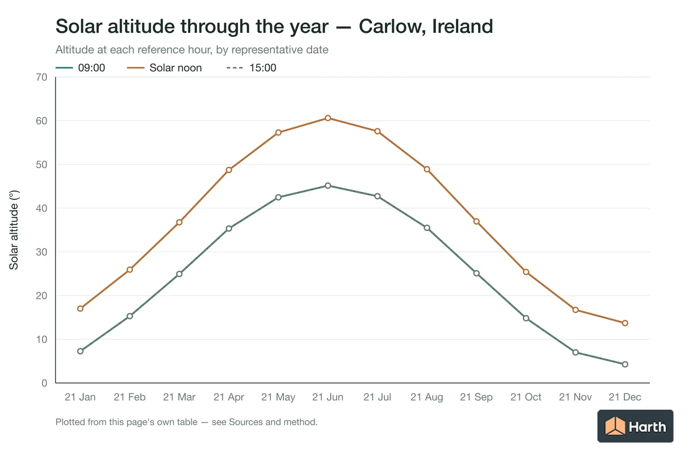
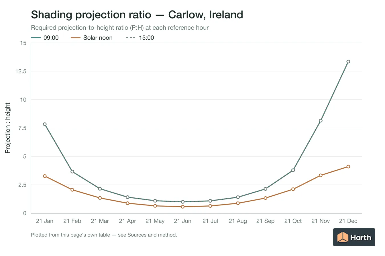
Carlow overhang sizing hand check
P:H is projection depth divided by the vertical facade distance to shade, calculated as 1 / tan(solar altitude). For a 1.20 m vertical target, multiply the table ratio by 1.20 m. The 09:00 and 15:00 columns use apparent solar time and show the solar-profile-plane ratio; they do not resolve facade azimuth, horizontal shadow displacement or a side-fin geometry.
The Carlow worksheet uses latitude 52.8408° and records longitude -6.9261°. A project study must replace the reference point, use the actual facade normal and obstruction mask, convert to civil time, test the full occupied period and account for diffuse sky, glazing and thermal performance. Refine solar positions with the NREL SPA.
Where can you explore related guidance?
- Explore all solar data guidance
- Sun Path: Carlow, Ireland
- Daylight & Orientation: Carlow, Ireland
- Solar Shading Design: Droichead Nua, Ireland
- Solar Shading Design: Kilkenny, Ireland
- All solar & daylight data guidance for Ireland
- Climate Design Data: Carlow, Ireland
- House Construction Cost Planning: Carlow, Ireland
- Office Construction Cost Planning: Carlow, Ireland
- Retail Construction Cost Planning: Carlow, Ireland
Sources and method
Location data from the GeoNames IE dump (CC BY 4.0, snapshot 2026-08-31, GeoNames ID 2965768). Regulatory starting point: Department of Housing, Local Government and Heritage and the local building-control authority. Figures are illustrative — verify against the current locally adopted edition for the site. Solar-method context: NOAA Solar Calculation Details; the Harth monthly table uses a simpler declination and geometric-daylight approximation whose stated limitations must be retained. Project-date refinement reference: NREL Solar Position Algorithm.
Source links
Frequently asked questions
What does the solar shading design record for Carlow establish?
The solar shading design record for Carlow establishes a reproducible discovery point at 52.8408, -6.9261 (GeoNames ID 2965768, administrative area L) and a Ireland source path. It does not establish a final project value, approval or parcel decision.
What must be replaced before using this solar shading design workflow for a project in Carlow?
For the solar shading design record in Carlow, replace the 52.8408, -6.9261 city reference with the surveyed site or parcel, identify the competent local authority, and verify the current documents under Building Regulations and Technical Guidance Documents. Record the edition, retrieval date, units, assumptions and named checker before relying on the result.
Related pages
- Solar Shading Design: Cairns, Australia
Solar shading design for Cairns, Australia: horizontal-overhang P:H ratios at 09:00, noon and 15:00 by month; June noon altitude 49.6°; sizing hand check.
- Solar Shading Design: Calgary, Canada
Solar shading design for Calgary, Canada: horizontal-overhang P:H ratios at 09:00, noon and 15:00 by month; June noon altitude 62.4°; sizing hand check.
- Solar Shading Design: Canberra, Australia
Solar shading design for Canberra, Australia: horizontal-overhang P:H ratios at 09:00, noon and 15:00 by month; June noon altitude 31.3°; sizing hand check.
- Solar Shading Design: Central Coast, Australia
Shading design for Central Coast, Australia: overhang P:H ratios at 09:00, noon and 15:00 by month; June noon altitude 33.1°.
- Solar Shading Design: Chennai, India
Solar shading design for Chennai, India: horizontal-overhang P:H ratios at 09:00, noon and 15:00 by month; June noon altitude 79.7°; sizing hand check.
- Solar Shading Design: Cluain Meala, Ireland
Solar shading design for Cluain Meala, Ireland: horizontal-overhang P:H ratios at 09:00, noon and 15:00 by month; June noon altitude 61.1°; sizing hand check.