Solar & Daylight Data
Sun Path: Hobart, Australia
Sunrise, sunset, day length and sun bearings for Hobart, Australia in local clock time, month by month.
On this page
Last updated September 25, 2026 · Location: GeoNames point -42.8794, 147.3294 ([GeoNames AU dump](https://download.geonames.org/export/dump/AU.zip), CC BY 4.0, ID 2163355); time zone Australia/Hobart from the same GeoNames record. Sun positions, sunrise and sunset calculated by Harth with [NOAA's solar calculator equations](https://gml.noaa.gov/grad/solcalc/calcdetails.html), including standard atmospheric refraction, for a sea-level horizon.
Direct answer
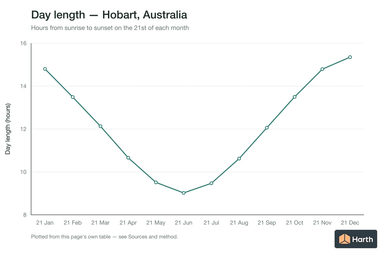
In Hobart, the shortest day (21 June) has 9 h 01 min of daylight, from sunrise at 07:41 to sunset at 16:42 AEST, and the longest (22 December) has 15 h 21 min, from 05:28 to 20:49 AEDT. The noon sun climbs from 23.7° to 70.6° above the horizon over the year. Sunrise moves between 58° (ENE) and 124° (SE) and sunset between 236° (SW) and 302° (WNW). The earliest sunrise is 05:25 on 10 December and the latest sunset is 20:52 on 2 January, which are not the solstice dates. In 2026 Hobart's clocks go back to AEST (UTC+10) on 5 April and forward to AEDT (UTC+11) on 4 October.
Content and cited inputs reviewed by Harth team · Published 2026-08-26 · Updated 2026-09-25.
When does the sun rise and set in Hobart each month?
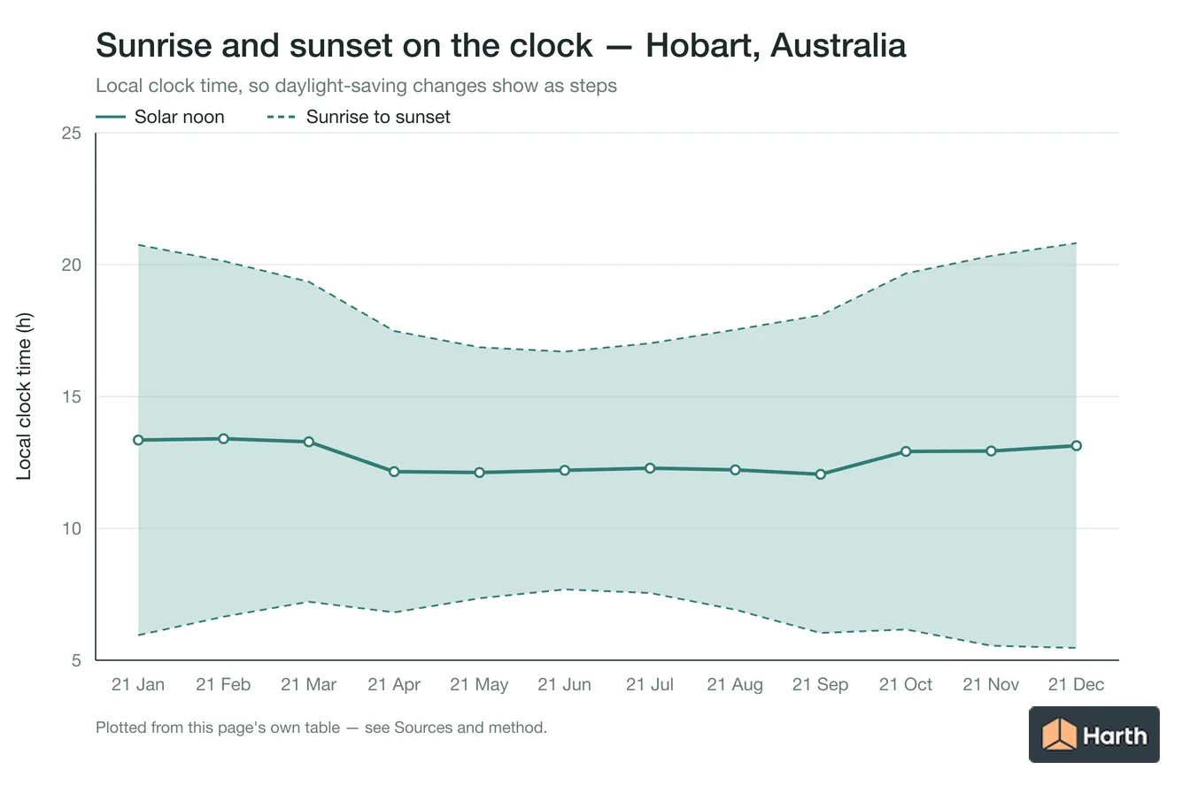
Times are local clock time on the 21st of each month in 2026, including daylight saving where it applies. Bearings are clockwise from true north.
| Date | Sunrise | Solar noon | Sunset | Day length | Noon altitude | Sunrise bearing | Sunset bearing | Clock |
|---|---|---|---|---|---|---|---|---|
| 21 January | 05:57 | 13:21 | 20:45 | 14.80 h | 67.1° | 119° (ESE) | 242° (WSW) | AEDT |
| 21 February | 06:39 | 13:24 | 20:08 | 13.49 h | 57.7° | 105° (ESE) | 255° (WSW) | AEDT |
| 21 March | 07:13 | 13:17 | 19:21 | 12.13 h | 46.9° | 91° (E) | 270° (W) | AEDT |
| 21 April | 06:49 | 12:09 | 17:29 | 10.66 h | 35.3° | 75° (ENE) | 286° (WNW) | AEST |
| 21 May | 07:21 | 12:07 | 16:52 | 9.51 h | 27.0° | 63° (ENE) | 297° (WNW) | AEST |
| 21 June | 07:41 | 12:12 | 16:42 | 9.02 h | 23.7° | 58° (ENE) | 302° (WNW) | AEST |
| 21 July | 07:33 | 12:17 | 17:01 | 9.47 h | 26.7° | 62° (ENE) | 298° (WNW) | AEST |
| 21 August | 06:55 | 12:13 | 17:32 | 10.62 h | 35.0° | 74° (ENE) | 286° (WNW) | AEST |
| 21 September | 06:02 | 12:03 | 18:05 | 12.06 h | 46.4° | 90° (E) | 270° (W) | AEST |
| 21 October | 06:10 | 12:55 | 19:40 | 13.50 h | 57.8° | 105° (ESE) | 254° (WSW) | AEDT |
| 21 November | 05:33 | 12:56 | 20:20 | 14.79 h | 67.0° | 118° (ESE) | 241° (WSW) | AEDT |
| 21 December | 05:28 | 13:08 | 20:49 | 15.35 h | 70.6° | 124° (SE) | 236° (SW) | AEDT |
How the sun moves over Hobart through the year
At -42.88° latitude the sunrise point swings 66° along the horizon over the year, from 58° (ENE) to 124° (SE), and sunset moves between 236° (SW) and 302° (WNW). On the shortest day the noon sun is 23.7° above the northern horizon; on 22 December it reaches 70.6°.
Solar noon falls at 12:03–13:24 on the clock through the year, because Hobart sits 2.7° of longitude from its time zone's reference meridian and the equation of time shifts noon by up to 16 minutes. Use the clock times in the table, not 12:00, when you set up a sun study.
Key sun dates for Hobart in 2026
- Shortest day: 21 June, 9 h 01 min (sunrise 07:41, sunset 16:42 AEST).
- Longest day: 22 December, 15 h 21 min (sunrise 05:28, sunset 20:49 AEDT).
- Earliest sunrise: 05:25 AEDT on 10 December. Latest sunset: 20:52 AEDT on 2 January.
- Highest noon sun: 70.6° on 22 December; lowest: 23.7° on 21 June.
- Clocks: In 2026 Hobart's clocks go back to AEST (UTC+10) on 5 April and forward to AEDT (UTC+11) on 4 October.
How these times were calculated
Harth computed each value with NOAA's solar-position equations for the GeoNames point -42.8794, 147.3294, using the standard 90.833° zenith for sunrise and sunset (refraction plus the sun's radius) and the Australia/Hobart time zone. Hills, buildings and elevation move the sunrise and sunset you actually see by a few minutes; use surveyed site coordinates and a horizon survey for a specific building.
Where can you explore related guidance?
- Explore all solar data guidance
- Sun Path: Launceston, Australia
- Sun Path: Geelong, Australia
- Sun Path: Melbourne, Australia
- All solar & daylight data guidance for Australia
- Climate Design Data: Hobart, Australia
- House Construction Cost Planning: Hobart, Australia
- Office Construction Cost Planning: Hobart, Australia
- Retail Construction Cost Planning: Hobart, Australia
Sources and method
Location: GeoNames point -42.8794, 147.3294 (GeoNames AU dump, CC BY 4.0, ID 2163355); time zone Australia/Hobart from the same GeoNames record. Sun positions, sunrise and sunset calculated by Harth with NOAA's solar calculator equations, including standard atmospheric refraction, for a sea-level horizon.
Source links
Frequently asked questions
What time is sunrise and sunset in Hobart on the longest day?
On 22 December 2026 the sun rises in Hobart at 05:28 and sets at 20:49 AEDT, giving 15 h 21 min of daylight.
Which direction does the sun rise and set in Hobart?
Sunrise in Hobart moves between 58° (ENE) and 124° (SE) over the year, and sunset between 236° (SW) and 302° (WNW). Only near the equinoxes does the sun rise due east and set due west.
Does Hobart use daylight saving time?
In 2026 Hobart's clocks go back to AEST (UTC+10) on 5 April and forward to AEDT (UTC+11) on 4 October. The sunrise and sunset times on this page include the change.
Related pages
- Sun Path: Hamilton, New Zealand
Sun path for Hamilton, New Zealand: solar-noon altitude 28.8° June, 52.2° equinox, 75.7° December; 9.4–14.6 h daylight; 12-month geometry table.
- Sun Path: Hastings, New Zealand
Sun path for Hastings, New Zealand: solar-noon altitude 26.9° June, 50.4° equinox, 73.8° December; 9.2–14.8 h daylight; 12-month geometry table.
- Sun Path: Hervey Bay, Australia
Sun path for Hervey Bay, Australia: solar-noon altitude 41.3° June, 64.7° equinox, 88.1° December; 10.4–13.6 h daylight; 12-month geometry table.
- Sun Path: Hong Kong, Hong Kong
Sun path for Hong Kong: solar-noon altitude 88.8° June, 67.7° equinox, 44.3° December; 10.6–13.4 h daylight; 12-month geometry table.
- Sun Path: Hyderabad, India
Sun path for Hyderabad, India: solar-noon altitude 83.9° June, 72.6° equinox, 49.2° December; 11.0–13.0 h daylight; 12-month geometry table.
- Sun Path: Ibadan, Nigeria
Sun path for Ibadan, Nigeria: solar-noon altitude 73.9° June, 82.6° equinox, 59.2° December; 11.6–12.4 h daylight; 12-month geometry table.