Solar & Daylight Data
Solar Altitude & Azimuth: Hobart, Australia
Hourly solar altitude and azimuth for Hobart, Australia in local clock time, for every month.
On this page
Last updated September 25, 2026 · Location: GeoNames point -42.8794, 147.3294 ([GeoNames AU dump](https://download.geonames.org/export/dump/AU.zip), CC BY 4.0, ID 2163355); time zone Australia/Hobart from the same GeoNames record. Sun positions, sunrise and sunset calculated by Harth with [NOAA's solar calculator equations](https://gml.noaa.gov/grad/solcalc/calcdetails.html), including standard atmospheric refraction, for a sea-level horizon.
Direct answer
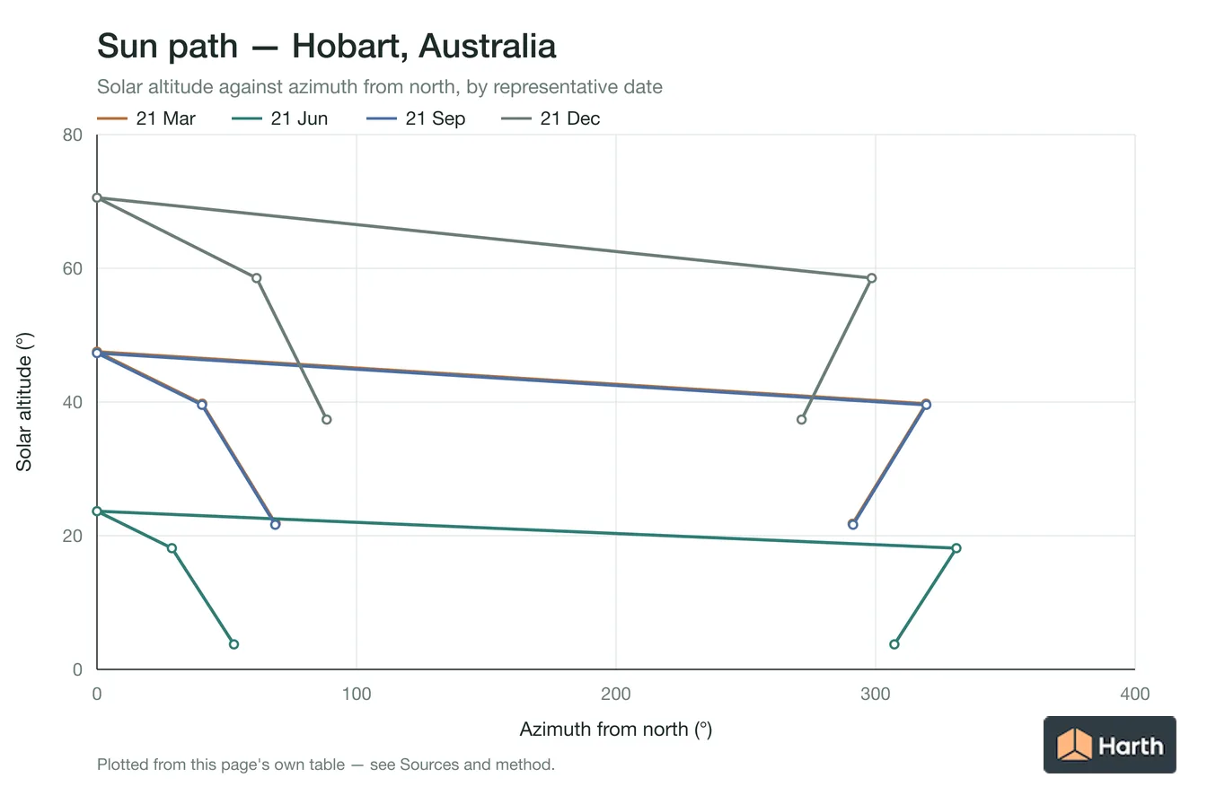
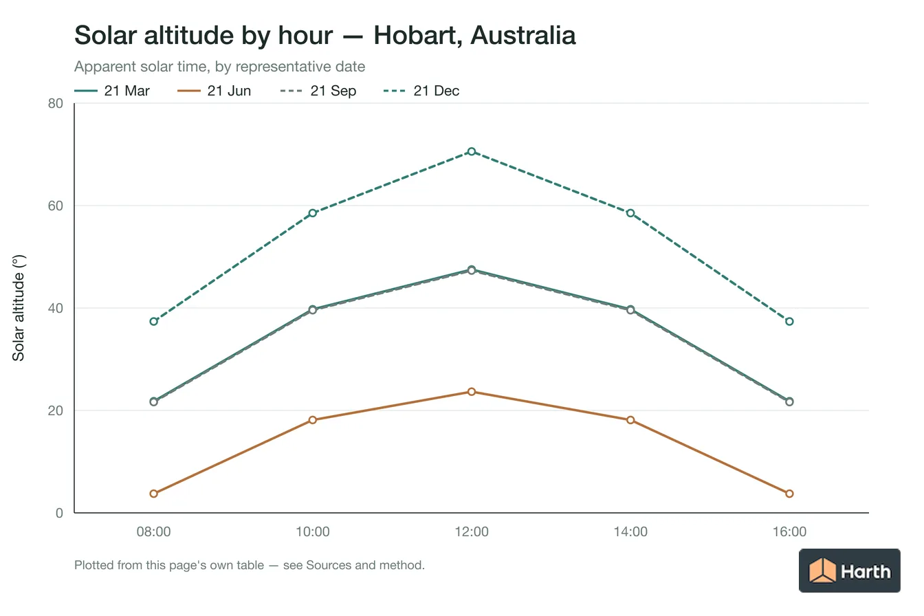
In Hobart the sun reaches its highest point of the year, 70.6°, at 13:09 AEDT on 22 December, and its lowest noon altitude, 23.7°, on 21 June. On 21 June it is 10.4° high at 09:00 and 13.4° at 15:00 local time, bearing 44° and 321° from north. At solar noon on 21 June (12:12 AEST) the sun bears 0° (N) at 23.7°. On 21 December it is 35.8° high at 09:00 and 59.9° at 15:00. The tables below give altitude and azimuth for every daylight hour on the 21st of each month in Australia/Hobart clock time, calculated with NOAA's solar equations for the city-centre point.
Content and cited inputs reviewed by Harth team · Published 2026-08-26 · Updated 2026-09-25.
Where is the sun over Hobart at each hour on the solstices and equinoxes?
| Representative date | Local time | Altitude | Azimuth from north |
|---|---|---|---|
| 21 March | 08:00 | 7.7° | 82.7° |
| 21 March | 09:00 | 18.4° | 71.9° |
| 21 March | 10:00 | 28.3° | 59.7° |
| 21 March | 11:00 | 37.0° | 45.2° |
| 21 March | 12:00 | 43.6° | 27.4° |
| 21 March | 13:00 | 46.8° | 6.6° |
| 21 March | 14:00 | 45.9° | 344.8° |
| 21 March | 15:00 | 41.2° | 325.1° |
| 21 March | 16:00 | 33.7° | 308.7° |
| 21 March | 17:00 | 24.4° | 295.2° |
| 21 March | 18:00 | 14.0° | 283.7° |
| 21 March | 19:00 | 3.3° | 273.3° |
| 21 June | 08:00 | 2.2° | 54.9° |
| 21 June | 09:00 | 10.4° | 43.9° |
| 21 June | 10:00 | 17.1° | 31.6° |
| 21 June | 11:00 | 21.7° | 17.9° |
| 21 June | 12:00 | 23.7° | 3.1° |
| 21 June | 13:00 | 22.8° | 348.2° |
| 21 June | 14:00 | 19.3° | 333.9° |
| 21 June | 15:00 | 13.4° | 321.0° |
| 21 June | 16:00 | 5.7° | 309.5° |
| 21 September | 07:00 | 9.7° | 79.8° |
| 21 September | 08:00 | 20.3° | 68.7° |
| 21 September | 09:00 | 30.0° | 56.1° |
| 21 September | 10:00 | 38.3° | 41.0° |
| 21 September | 11:00 | 44.1° | 22.5° |
| 21 September | 12:00 | 46.4° | 1.4° |
| 21 September | 13:00 | 44.6° | 340.1° |
| 21 September | 14:00 | 39.2° | 321.2° |
| 21 September | 15:00 | 31.3° | 305.6° |
| 21 September | 16:00 | 21.7° | 292.7° |
| 21 September | 17:00 | 11.2° | 281.5° |
| 21 September | 18:00 | 0.7° | 271.1° |
| 21 December | 06:00 | 4.4° | 118.4° |
| 21 December | 07:00 | 14.3° | 108.9° |
| 21 December | 08:00 | 24.9° | 99.7° |
| 21 December | 09:00 | 35.8° | 90.0° |
| 21 December | 10:00 | 46.7° | 78.8° |
| 21 December | 11:00 | 57.2° | 64.1° |
| 21 December | 12:00 | 65.9° | 41.5° |
| 21 December | 13:00 | 70.5° | 5.9° |
| 21 December | 14:00 | 67.8° | 327.2° |
| 21 December | 15:00 | 59.9° | 301.3° |
| 21 December | 16:00 | 49.8° | 284.9° |
| 21 December | 17:00 | 39.0° | 273.0° |
| 21 December | 18:00 | 28.0° | 263.0° |
| 21 December | 19:00 | 17.3° | 253.7° |
| 21 December | 20:00 | 7.1° | 244.3° |
Hobart solar altitude at each hour, month by month
| Local time | Jan | Feb | Mar | Apr | May | Jun | Jul | Aug | Sep | Oct | Nov | Dec |
|---|---|---|---|---|---|---|---|---|---|---|---|---|
| 06:00 | 0° | — | — | — | — | — | — | — | — | — | 4° | 4° |
| 07:00 | 10° | 3° | — | 1° | — | — | — | 0° | 10° | 8° | 14° | 14° |
| 08:00 | 20° | 14° | 8° | 11° | 5° | 2° | 4° | 10° | 20° | 19° | 25° | 25° |
| 09:00 | 31° | 25° | 18° | 20° | 14° | 10° | 12° | 19° | 30° | 30° | 36° | 36° |
| 10:00 | 42° | 35° | 28° | 28° | 21° | 17° | 19° | 27° | 38° | 40° | 47° | 47° |
| 11:00 | 52° | 45° | 37° | 33° | 25° | 22° | 24° | 32° | 44° | 49° | 56° | 57° |
| 12:00 | 61° | 53° | 44° | 35° | 27° | 24° | 27° | 35° | 46° | 56° | 64° | 66° |
| 13:00 | 67° | 57° | 47° | 34° | 26° | 23° | 26° | 34° | 45° | 58° | 67° | 70° |
| 14:00 | 66° | 57° | 46° | 30° | 22° | 19° | 22° | 30° | 39° | 55° | 63° | 68° |
| 15:00 | 59° | 52° | 41° | 23° | 16° | 13° | 16° | 23° | 31° | 48° | 55° | 60° |
| 16:00 | 50° | 43° | 34° | 14° | 7° | 6° | 9° | 15° | 22° | 39° | 45° | 50° |
| 17:00 | 39° | 33° | 24° | 4° | — | — | — | 5° | 11° | 28° | 35° | 39° |
| 18:00 | 28° | 23° | 14° | — | — | — | — | — | 1° | 17° | 24° | 28° |
| 19:00 | 17° | 12° | 3° | — | — | — | — | — | — | 7° | 13° | 17° |
| 20:00 | 7° | 1° | — | — | — | — | — | — | — | — | 3° | 7° |
Hobart solar azimuth at each hour, month by month
| Local time | Jan | Feb | Mar | Apr | May | Jun | Jul | Aug | Sep | Oct | Nov | Dec |
|---|---|---|---|---|---|---|---|---|---|---|---|---|
| 06:00 | 118° | — | — | — | — | — | — | — | — | — | 114° | 118° |
| 07:00 | 108° | 102° | — | 73° | — | — | — | 73° | 80° | 97° | 104° | 109° |
| 08:00 | 99° | 92° | 83° | 62° | 56° | 55° | 58° | 63° | 69° | 87° | 95° | 100° |
| 09:00 | 89° | 81° | 72° | 50° | 45° | 44° | 47° | 51° | 56° | 76° | 84° | 90° |
| 10:00 | 78° | 70° | 60° | 36° | 32° | 32° | 34° | 37° | 41° | 63° | 72° | 79° |
| 11:00 | 64° | 55° | 45° | 20° | 17° | 18° | 20° | 22° | 23° | 46° | 56° | 64° |
| 12:00 | 43° | 36° | 27° | 3° | 2° | 3° | 4° | 4° | 1° | 25° | 32° | 42° |
| 13:00 | 13° | 11° | 7° | 345° | 346° | 348° | 349° | 346° | 340° | 358° | 358° | 6° |
| 14:00 | 338° | 344° | 345° | 328° | 331° | 334° | 334° | 330° | 321° | 332° | 325° | 327° |
| 15:00 | 310° | 320° | 325° | 314° | 318° | 321° | 320° | 315° | 306° | 311° | 302° | 301° |
| 16:00 | 292° | 302° | 309° | 302° | 306° | 309° | 308° | 303° | 293° | 295° | 286° | 285° |
| 17:00 | 279° | 288° | 295° | 291° | — | — | — | 291° | 282° | 282° | 274° | 273° |
| 18:00 | 268° | 277° | 284° | — | — | — | — | — | 271° | 271° | 264° | 263° |
| 19:00 | 259° | 266° | 273° | — | — | — | — | — | — | 261° | 255° | 254° |
| 20:00 | 249° | 256° | — | — | — | — | — | — | — | — | 245° | 244° |
Reading the Hobart angle tables
Altitude is the sun's height above the horizon; azimuth is its bearing clockwise from true north. Hours are local clock time, so rows shift by an hour across a daylight-saving change. On 21 June the sun stands 10.4° high at 09:00 (bearing 44° (NE)) and 13.4° at 15:00 (321° (NW)); those are the angles to test winter overshadowing from neighbouring buildings. On 21 December the same hours give 35.8° and 59.9°.
How these angles were calculated
Harth applied NOAA's solar-position equations, with standard atmospheric refraction, to the GeoNames point -42.8794, 147.3294 and converted each hour with the Australia/Hobart time zone. The angles hold to within about a tenth of a degree across the city centre; a site several kilometres away, or one with a raised horizon, should be recalculated from its own coordinates.
Where can you explore related guidance?
- Explore all solar data guidance
- Sun Path: Hobart, Australia
- Solar Shading Design: Hobart, Australia
- Daylight & Orientation: Hobart, Australia
- Solar Altitude & Azimuth: Launceston, Australia
- All solar & daylight data guidance for Australia
- Climate Design Data: Hobart, Australia
- House Construction Cost Planning: Hobart, Australia
- Office Construction Cost Planning: Hobart, Australia
- Retail Construction Cost Planning: Hobart, Australia
Sources and method
Location: GeoNames point -42.8794, 147.3294 (GeoNames AU dump, CC BY 4.0, ID 2163355); time zone Australia/Hobart from the same GeoNames record. Sun positions, sunrise and sunset calculated by Harth with NOAA's solar calculator equations, including standard atmospheric refraction, for a sea-level horizon.
Source links
Frequently asked questions
How high is the sun at noon in Hobart in winter?
On 21 June the sun in Hobart reaches 23.7° at solar noon, 12:12 AEST, bearing 0° (N). The lowest noon sun of 2026 is 23.7° on 21 June.
Where is the sun at 3 pm in Hobart?
At 15:00 local time the sun in Hobart is 13.4° high at 321° (NW) on 21 June, and 59.9° high at 301° (WNW) on 21 December.
When is the sun highest in Hobart?
The sun is highest in Hobart on 22 December, when it reaches 70.6° at 13:09 AEDT.
Related pages
- Solar Altitude & Azimuth: Halifax, Canada
Solar altitude and azimuth for Halifax, Canada: hourly altitude/azimuth matrix 08:00–16:00 on 12 dates; noon altitude 68.8° June, 21.9° December.
- Solar Altitude & Azimuth: Hamilton, Canada
Solar altitude and azimuth for Hamilton, Canada: hourly altitude/azimuth matrix 08:00–16:00 on 12 dates; noon altitude 70.2° June, 23.3° December.
- Solar Altitude & Azimuth: Hervey Bay, Australia
Solar altitude and azimuth for Hervey Bay, Australia: hourly altitude/azimuth matrix 08:00–16:00 on 12 dates; noon altitude 41.3° June, 88.1° December.
- Solar Altitude & Azimuth: Hong Kong, Hong Kong
Solar altitude and azimuth for Hong Kong: hourly altitude/azimuth matrix 08:00–16:00 on 12 dates; noon altitude 88.8° June, 44.3° December.
- Solar Altitude & Azimuth: Hyderabad, India
Solar altitude and azimuth for Hyderabad, India: hourly altitude/azimuth matrix 08:00–16:00 on 12 dates; noon altitude 83.9° June, 49.2° December.
- Solar Altitude & Azimuth: Indore, India
Solar altitude and azimuth for Indore, India: hourly altitude/azimuth matrix 08:00–16:00 on 12 dates; noon altitude 89.3° June, 43.8° December.