Solar & Daylight Data
Solar Altitude and Azimuth: Meaning, Formulas & Worked Example
Definitions of solar altitude, azimuth, and solar noon, and how they change with season and latitude — with computed noon-altitude values for the solstices and equinox.
On this page
Last updated August 14, 2026 · NOAA Solar Calculator / standard solar geometry equations. Noon altitude computed as 90 - |latitude - declination|, with declination taken as +23.44 (summer solstice), 0 (equinox), and -23.44 (winter solstice). Values are approximate and ignore atmospheric refraction and the equation of time. Official references: [NOAA solar calculation details](https://www.gml.noaa.gov/grad/solcalc/solareqns.PDF). Altitude, azimuth and declination formulas: PVEducation ([elevation](https://www.pveducation.org/pvcdrom/properties-of-sunlight/elevation-angle), [azimuth](https://www.pveducation.org/pvcdrom/properties-of-sunlight/azimuth-angle), [declination](https://www.pveducation.org/pvcdrom/properties-of-sunlight/declination-angle)); axial tilt 23.44 degrees: [NASA Earth fact sheet](https://nssdc.gsfc.nasa.gov/planetary/factsheet/earthfact.html). Worked example and 40 degrees N table computed from these equations (geometric, no refraction).
Direct answer
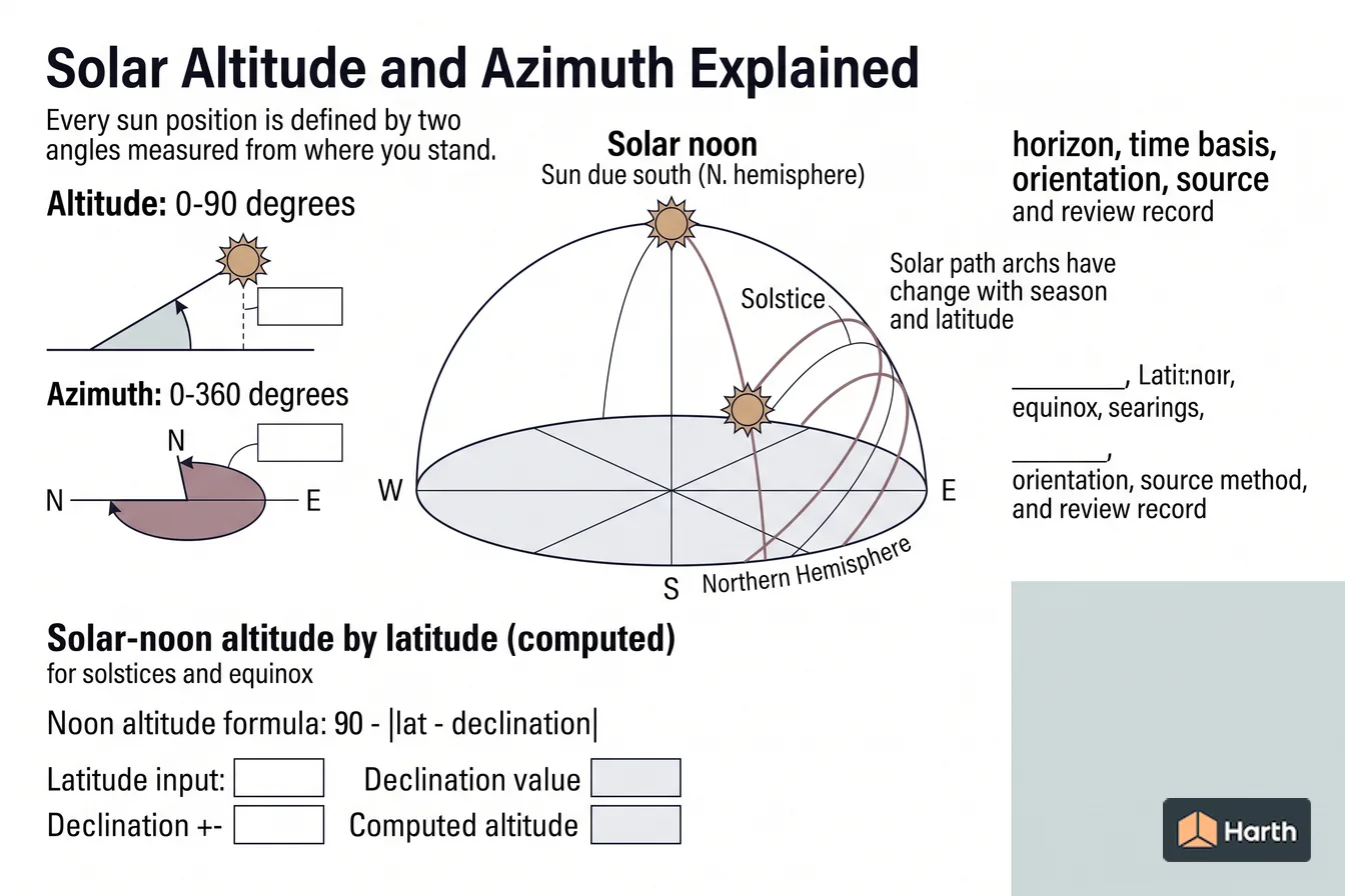
Definitions of solar altitude, azimuth, and solar noon, and how they change with season and latitude — with computed noon-altitude values for the solstices and equinox. A key reference is altitude: 0-90 degrees; check the cited source, edition, units, and applicability before using it for design, compliance, procurement, or approval. Altitude is 0-90 degrees; sun height above horizon. Azimuth is 0-360 degrees; compass bearing of the sun. Solar noon is Sun due south (N. hemisphere); daily peak altitude. Every sun position is defined by two angles measured from where you stand: Read the values with the cited source, edition or observation period, units and applicability; replace illustrative inputs with current project evidence before design, procurement or approval use. Retain the source file, retrieval date, assumptions and named checker in the project record so the result can be reproduced and reviewed when the governing information changes.
Content and cited inputs reviewed by Harth team · Published 2026-08-14 · Updated 2026-08-14.
What does this term mean?
Solar Altitude and Azimuth Explained: Definitions of solar altitude, azimuth, and solar noon, and how they change with season and latitude — with computed noon-altitude values for the solstices and equinox.
What are the key takeaways?
- Altitude: 0-90 degrees
- Azimuth: 0-360 degrees
- Solar noon: Sun due south (N. hemisphere)
- Noon altitude formula: 90 - |lat - declination|
Which solar conditions control the result?
Every sun position is defined by two angles measured from where you stand:
- Solar altitude is the angle of the sun above the horizon. It is 0 degrees at sunrise and sunset and reaches its daily maximum at solar noon.
- Solar azimuth is the sun's horizontal bearing, measured as a compass direction. It tells you which facade the sun is facing at any moment.
Solar noon
Solar noon is when the sun crosses the meridian and hits its highest point of the day — due south in the northern hemisphere. Because it is the daily peak, the noon altitude is the single most useful number for shading design. At solar noon the altitude is:
$$ \text{noon altitude} = 90 - |,\text{latitude} - \text{declination},| $$
where solar declination is about +23.44 degrees at the summer solstice, 0 degrees at the equinoxes, and -23.44 degrees at the winter solstice.
Solar-noon altitude by latitude (computed)
The table below applies the formula above. Values are approximate — they use mean declination and ignore atmospheric refraction.
| Latitude (N) | Summer solstice | Equinox | Winter solstice |
|---|---|---|---|
| 0 degrees (equator) | 66.6 degrees | 90.0 degrees | 66.6 degrees |
| 25 degrees | 88.4 degrees | 65.0 degrees | 41.6 degrees |
| 33.4 degrees (Phoenix) | 80.0 degrees | 56.6 degrees | 33.2 degrees |
| 40 degrees | 73.4 degrees | 50.0 degrees | 26.6 degrees |
| 51.5 degrees (London) | 61.9 degrees | 38.5 degrees | 15.1 degrees |
Reading down a column shows how the sun sinks lower as you move toward the poles. Reading across a row shows the seasonal swing — always about 46.9 degrees between the two solstices, twice the axial tilt.
Altitude, elevation, zenith and azimuth: which is which
| Term | Meaning | Range and convention |
|---|---|---|
| Solar altitude (solar elevation) | Height of the sun above the horizon; the two names mean the same angle | 0 degrees at the horizon, 90 degrees directly overhead |
| Solar zenith angle | Angle between the sun and straight up | Zenith = 90 degrees - altitude |
| Solar azimuth | Horizontal compass direction the sunlight comes from | NOAA and most tools: clockwise from north (N 0, E 90, S 180, W 270); some texts use south = 0 and ±180 degrees |
| Hour angle (h) | How far the sun has turned from solar noon | 15 degrees per hour; negative in the morning, positive in the afternoon |
| Declination (δ) | Latitude at which the sun is directly overhead that day | About +23.44 to -23.44 degrees over the year |
Before comparing numbers from two tools, check which azimuth reference each uses: a south-referenced azimuth of 0 degrees is due south, which a north-referenced tool reports as 180 degrees.
Solar altitude and azimuth formulas
These are the standard spherical-geometry relations, as published in NOAA's solar position calculation notes and PVEducation's pages on elevation, azimuth and declination. φ is latitude (positive north), n is the day of the year (1 January = 1).
Declination (Cooper's approximation):
$$ \delta \approx 23.45 \times \sin\left[\frac{360}{365},(284 + n)\right] $$
The 23.45 coefficient is Earth's axial tilt — the reason the sun's overhead latitude swings between the tropics. NASA's Earth fact sheet currently gives the obliquity as 23.44 degrees, the value this page's tables use; the 0.01 degree difference is immaterial for design. NOAA's own calculator uses a longer Fourier series for declination.
Hour angle:
$$ h = 15 \times (\text{solar time in hours} - 12) $$
Solar altitude angle:
$$ \sin\alpha = \sin\varphi,\sin\delta + \cos\varphi,\cos\delta,\cos h $$
NOAA writes the same equation for the zenith angle, since cos(zenith) = sin(altitude). At solar noon h = 0 and it reduces to the noon formula above.
Solar azimuth (clockwise from north):
$$ \cos A = \frac{\sin\delta,\cos\varphi - \cos\delta,\sin\varphi,\cos h}{\cos\alpha} $$
Arccos only returns 0–180 degrees, so use A as calculated in the morning (negative h) and 360 - A in the afternoon (positive h).
Solar time is not clock time. NOAA converts with a time offset in minutes of eqtime + 4 × longitude - 60 × timezone (longitude positive east, timezone in hours from UTC).
Worked example: 40 degrees N, 21 June, 3:00 pm solar time
Inputs: latitude φ = 40 degrees N, day n = 172 (21 June, non-leap year), solar time 15:00.
| Step | Working | Result |
|---|---|---|
| Declination | 23.45 × sin[360/365 × (284 + 172)] | δ ≈ +23.45 degrees |
| Hour angle | 15 × (15 - 12) | h = +45 degrees |
| sin α | sin 40 × sin 23.45 + cos 40 × cos 23.45 × cos 45 = 0.2558 + 0.4969 | 0.7527 |
| Altitude | arcsin 0.7527 | α ≈ 48.8 degrees |
| Zenith angle | 90 - 48.8 | ≈ 41.2 degrees |
| cos A | (sin 23.45 × cos 40 - cos 23.45 × sin 40 × cos 45) ÷ cos 48.8 = -0.1121 ÷ 0.6583 | -0.1703 |
| Azimuth | arccos(-0.1703) = 99.8; afternoon, so 360 - 99.8 | A ≈ 260.2 degrees |
At 3:00 pm solar time the sun is about 49 degrees up and about 10 degrees south of due west — the angle a west facade and its shading must deal with on the longest day. At 9:00 am (h = -45 degrees) the altitude is the same and the azimuth mirrors it at 99.8 degrees. The noon check, 90 - |40 - 23.45| = 73.45 degrees, matches the 40 degree row of the table above.
Sun altitude and azimuth at 40 degrees N through the year (computed)
Computed with the formulas above for a site at 40 degrees N, using declinations of +23.44, 0 and -23.44 degrees. Each cell is altitude / azimuth.
| Date | 9:00 solar time | Solar noon | 15:00 solar time | Sunrise azimuth |
|---|---|---|---|---|
| June solstice | 48.8 / 99.8 | 73.4 / 180 | 48.8 / 260.2 | 58.7 (north of east) |
| Equinox | 32.8 / 122.7 | 50.0 / 180 | 32.8 / 237.3 | 90.0 (due east) |
| December solstice | 14.0 / 138.0 | 26.6 / 180 | 14.0 / 222.0 | 121.3 (south of east) |
Sunrise azimuths are geometric (sun's centre on a flat horizon, no refraction); NOAA times sunrise at a zenith of 90.833 degrees to allow for refraction and the solar disc, so observed sunrise comes slightly earlier. Sunset azimuths mirror sunrise about due south (for example 301.3 degrees in June).
Why this matters in design
- A high summer noon altitude means a modest horizontal overhang can shade south glazing at the hottest time of year.
- A low winter noon altitude means that same overhang still admits low-angle winter sun for passive heating and daylight.
- Low-latitude sites face near-overhead summer sun (little help from vertical shading) but strong east/west low-angle exposure; high-latitude sites deal with low sun year-round and long shadows.
For a full worked example, see sun path and solar angles for Phoenix, AZ, and read understanding sun-path diagrams for how these angles are plotted.
Solar Altitude and Azimuth: Meaning, Formulas & Worked Example: reproducibility record
| Solar input | Project entry |
|---|---|
| Latitude / longitude and coordinate source | — |
| Time zone and daylight-saving treatment | — |
| Date, clock time and time basis | — |
| North convention and surface orientation | — |
| Solar-position algorithm / software and version | — |
| Atmospheric or horizon assumptions | — |
| Calculated altitude / azimuth and units | — |
| Independent check and reviewer | — |
Project-use verification: retain the inputs and method with every plotted result. A diagram without its coordinates, time basis and algorithm is illustrative only.
Where can you explore related guidance?
- Explore all solar data guidance
- Understanding Sun-Path Diagrams
- Sun Path & Solar Angles for Phoenix, AZ
Sources and method
NOAA Solar Calculator / standard solar geometry equations. Noon altitude computed as 90 - |latitude - declination|, with declination taken as +23.44 (summer solstice), 0 (equinox), and -23.44 (winter solstice). Values are approximate and ignore atmospheric refraction and the equation of time. Official references: NOAA solar calculation details. Altitude, azimuth and declination formulas: PVEducation (elevation, azimuth, declination); axial tilt 23.44 degrees: NASA Earth fact sheet. Worked example and 40 degrees N table computed from these equations (geometric, no refraction).
Source links
Frequently asked questions
What is solar noon, and is it the same as clock noon?
Solar noon is the instant the sun crosses the local meridian and reaches its highest altitude of the day — due south in the northern hemisphere, due north in the southern. It is almost never exactly 12:00 on the clock: it shifts with your longitude within a time zone, with daylight saving time, and by up to about 16 minutes over the year due to the equation of time. For design geometry, solar noon is the moment that matters because it fixes the day's peak sun altitude.
How do altitude and azimuth change with season and latitude?
Altitude rises in summer and falls in winter because the sun's declination swings between +23.44 and -23.44 degrees. Moving toward the poles lowers the whole envelope: at higher latitudes the noon sun is lower year-round and the azimuth sweeps through a wider arc in summer, with the sun rising well north of east and setting well north of west. Near the equator the noon sun passes close to overhead and the seasonal swing is small.
Why is the winter noon sun so much lower than the summer sun?
The difference is twice the axial tilt — about 46.9 degrees — between summer and winter solstice noon altitude at any latitude. That large swing is exactly why fixed horizontal overhangs work: a device sized to block the high summer sun will still let the much lower winter sun reach the glass and warm the space.
What does solar altitude mean?
Solar altitude — also called solar elevation — is the angle of the sun above the horizon, measured from where you stand. It is 0 degrees at sunrise and sunset and peaks at solar noon; its complement, 90 degrees minus the altitude, is the zenith angle. Altitude governs shadow length and how deep sunlight reaches into a room, so it drives overhang depth, shading-device design and site shadow studies.
What is the formula for the solar altitude angle?
sin(altitude) = sin(latitude) × sin(declination) + cos(latitude) × cos(declination) × cos(hour angle). The hour angle is 15 degrees per hour from solar noon, negative before noon, and declination runs from about +23.44 degrees in June to -23.44 degrees in December. At solar noon the hour angle is zero and the result simplifies to altitude = 90 - |latitude - declination|.
What is the sun's azimuth, and is it measured from north or south?
Solar azimuth is the horizontal compass direction of the sun. NOAA and most current software measure it clockwise from true north, so due east is 90 degrees, due south 180 and due west 270. Some solar-engineering texts instead measure from due south, with 0 degrees meaning south. Confirm which reference a tool or dataset uses, and remember azimuths are relative to true north, not magnetic north.
Why does 23.44 degrees matter for sun angles?
23.44 degrees is Earth's axial tilt (obliquity) as listed in NASA's Earth fact sheet. Because of that tilt, the sun's declination swings between about +23.44 degrees at the June solstice and -23.44 degrees at the December solstice. That swing sets the tropics and polar circles, and it makes the noon sun at any latitude about 46.9 degrees higher at one solstice than the other.
Related pages
- Solar & Daylight Data: Nigeria
Nigeria solar & daylight data for architects: 42 city pages covering sun path, each with a reproducible location record and source path.
- Solar & Daylight Data: Philippines
Philippines solar & daylight data for architects: 17 city pages covering sun path, each with a reproducible location record and source path.
- Solar & Daylight Data: Singapore
Singapore solar & daylight data for architects: 1 city pages, each with a reproducible location record and source path.
- Solar Altitude & Azimuth: Abu Dhabi, UAE
Solar altitude and azimuth for Abu Dhabi, UAE: hourly altitude/azimuth matrix 08:00–16:00 on 12 dates; noon altitude 89.0° June, 42.1° December.
- Solar Altitude & Azimuth: Adelaide, Australia
Solar altitude and azimuth for Adelaide, Australia: hourly altitude/azimuth matrix 08:00–16:00 on 12 dates; noon altitude 31.6° June, 78.5° December.
- Solar Altitude & Azimuth: Agra, India
Solar altitude and azimuth for Agra, India: hourly altitude/azimuth matrix 08:00–16:00 on 12 dates; noon altitude 86.3° June, 39.4° December.