Structural Design Loads
Design Wind Speed (Vult), Risk Category Maps & Exposure B/C/D
Plain-language guide to ultimate design wind speed (Vult), exposure categories B/C/D, and how risk category selects the right wind map for a project.
On this page
Last updated August 14, 2026 · Concepts per ASCE 7 (Ch. 26–30); mapped basic wind speeds by risk category from the ASCE Hazard Tool. Any values shown are illustrative and the official ASCE Hazard Tool + AHJ-adopted code govern. Official references: [ASCE Hazard Tool](https://ascehazardtool.org/); [ASCE/SEI 7-22](https://www.asce.org/publications-and-news/codes-and-standards/asce-sei-7-22); [2024 IBC Chapter 16](https://codes.iccsafe.org/content/IBC2024P1/chapter-16-structural-design); [2021 IBC Chapter 16](https://codes.iccsafe.org/content/IBC2021P2/chapter-16-structural-design); [FEMA fact sheet: ASCE 7-22 wind load changes](https://www.fema.gov/sites/default/files/documents/fema_asce-7-22-wind-highlights_fact-sheet_2022.pdf).
Direct answer
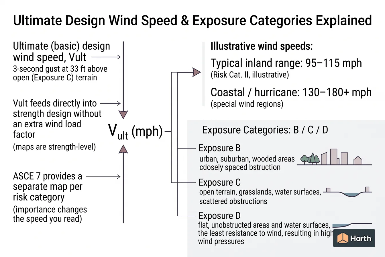
Plain-language guide to ultimate design wind speed (Vult), exposure categories B/C/D, and how risk category selects the right wind map for a project. A key reference is typical inland range: 95–115 mph; check the cited source, edition, units, and applicability before using it for design, compliance, procurement, or approval. Symbol is Vult (mph); ultimate/basic design wind speed. Typical inland range is 95–115 mph; Risk Cat. II, illustrative. Coastal / hurricane is 130–180+ mph; special wind regions. The ultimate (basic) design wind speed, Vult, in mph, is a 3-second gust at 33 ft above open (Exposure C) terrain. Since ASCE 7-10 the maps are strength-level, so Vult feeds directly into strength design without an extra wind load factor. ASCE 7 provides a separate map per risk category, so importance changes the speed you read.
Content and cited inputs reviewed by Harth team · Published 2026-08-14 · Updated 2026-08-14.
What does this term mean?
Ultimate Design Wind Speed & Exposure Categories Explained: Plain-language guide to ultimate design wind speed (Vult), exposure categories B/C/D, and how risk category selects the right wind map for a project.
Which site and code inputs control the design?
The ultimate (basic) design wind speed, Vult, in mph, is a 3-second gust at 33 ft above open (Exposure C) terrain. Since ASCE 7-10 the maps are strength-level, so Vult feeds directly into strength design without an extra wind load factor. ASCE 7 provides a separate map per risk category, so importance changes the speed you read.
| Risk Category | Building type | Return period |
|---|---|---|
| I | Low hazard (minor storage) | ~300 yr |
| II | Standard (most buildings) | ~700 yr |
| III | Substantial hazard (assembly) | ~1,700 yr |
| IV | Essential (hospitals, EOCs) | ~3,000 yr |
Which risk category wind map applies
There is no separate "wind risk category map". Set the risk category from the building's use and occupant load under IBC Table 1604.5, then read the speed from the map drawn for that category:
| Risk Category | Typical triggers (2024 IBC Table 1604.5, abridged) | 2024 IBC wind map |
|---|---|---|
| I | Low hazard to life: agricultural facilities, certain temporary facilities, minor storage | Figure 1609.3(1) |
| II | Everything not listed in I, III or IV | Figure 1609.3(2) |
| III | Primary occupancy public assembly over 300; Group E or I-4 over 250; education above 12th grade over 500; any occupancy over 5,000 | Figure 1609.3(3) |
| IV | Essential facilities: Group I-2 Condition 2, fire, rescue, ambulance and police stations, designated emergency shelters, emergency operations centers | Figure 1609.3(4) |
The 2021 IBC spreads the same four categories over Figures 1609.3(1)–(12). The 2021 and 2024 IBC both call the mapped value the basic design wind speed, V; the 2015 IBC called it the ultimate design wind speed, Vult. Either way it is a 3-second gust at 33 ft in Exposure C, and the 2024 IBC points to the ASCE Wind Design Geodatabase for location-specific values.
ASCE 7-22, the standard behind the 2024 IBC, revised the maps mainly in hurricane-prone regions. FEMA's summary lists decreases along the North Atlantic coast (the 130 mph Risk Category II contour moved offshore), increases on the south Texas coast (about 10 mph) and in parts of the western Florida panhandle, and slight decreases on the Alabama, Mississippi and Louisiana coasts. Examples for Risk Category II: Mobile, AL went from 154 to 146 mph and Destin, FL from 142 to 152 mph. The Risk Category I, III and IV maps moved in the same way.
Exposure categories
Exposure describes the upwind ground roughness and can vary by wind direction:
- Exposure B — urban, suburban, wooded; the most sheltered, lowest pressures.
- Exposure C — open terrain with scattered obstructions; the common default.
- Exposure D — flat, unobstructed terrain, shorelines, and open water; highest pressures.
Moving from B toward D raises wind pressure meaningfully at low heights, so the exposure call is not a formality.
Exposure B, C and D: the upwind distance rules
For each wind direction, check the two 45° sectors either side of it and use whichever exposure gives the higher load (2024 IBC Section 1609.4.1, following ASCE 7 Section 26.7). Classify the upwind surface roughness, then test the fetch:
| Exposure | Upwind ground | Required fetch (2024 IBC Section 1609.4.3) |
|---|---|---|
| B | Surface Roughness B: urban, suburban or wooded, with numerous closely spaced obstructions the size of single-family dwellings or larger | 1,500 ft for mean roof height ≤ 30 ft; the greater of 2,600 ft or 20× building height above 30 ft |
| C | Any site that does not qualify as B or D; Surface Roughness C is open terrain with scattered obstructions generally under 30 ft, flat open country and grassland | None |
| D | Surface Roughness D: flat, unobstructed areas and water surfaces, including mud flats, salt flats and unbroken ice | The greater of 5,000 ft or 20× building height |
Exposure D also reaches inland. A site with B or C roughness immediately upwind is still Exposure D if it lies within the greater of 600 ft or 20× building height of a D condition. Buildings taller than 130 ft therefore need more than 2,600 ft of suburban fabric upwind to qualify for B. ASCE 7-22 also revised the velocity pressure coefficient Kz (Section 26.10), the factor through which exposure changes pressure, so confirm pressures against the edition your jurisdiction has adopted.
Illustrative wind speeds
| Setting | Illustrative Vult (Risk Cat. II) |
|---|---|
| Interior low-wind region | 95–105 mph |
| Transitional / plains | 105–120 mph |
| Hurricane-prone coast | 130–180+ mph |
Get the authoritative value
Read the exact Vult for each risk category from the ASCE Hazard Tool at your project address, then set exposure from the actual surrounding terrain. To sanity-check terrain and exposure against real surroundings, drop the address into Harth and study the site context before your engineer finalizes the wind design.
Design Wind Speed (Vult), Risk Category Maps & Exposure B/C/D: structural-engineer handoff record
| Required input | Project entry |
|---|---|
| Site coordinates and jurisdiction | — |
| Adopted code / standard and edition | — |
| Risk category and occupancy basis | — |
| Official hazard-tool result and retrieval date | — |
| Site class, exposure, terrain or other relevant site input | — |
| Local amendments and authority confirmation | — |
| Engineer's derived design values | — |
| Engineer, checker and revision | — |
Stop condition: this page explains terminology and source workflow only. A generated diagram, map colour or generic example must not become a project design value.
Where can you explore related guidance?
- Explore all structural loads guidance
- Ground Snow Load (pg) Explained for Architects
- Seismic Design Category & Site Class Explained (SDC A–F)
Sources and method
Concepts per ASCE 7 (Ch. 26–30); mapped basic wind speeds by risk category from the ASCE Hazard Tool. Any values shown are illustrative and the official ASCE Hazard Tool + AHJ-adopted code govern. Official references: ASCE Hazard Tool; ASCE/SEI 7-22; 2024 IBC Chapter 16; 2021 IBC Chapter 16; FEMA fact sheet: ASCE 7-22 wind load changes.
Source links
Frequently asked questions
What does 'ultimate' design wind speed mean?
Since ASCE 7-10, wind maps give the ultimate (strength-level) basic wind speed Vult — a 3-second gust at 33 ft in Exposure C, tied to a return period that varies by risk category. It is used directly in strength design load combinations, so it is not multiplied by a load factor the way older allowable-stress (Vasd) speeds were. Confirm which speed a legacy calculation uses before comparing numbers.
How do I pick an exposure category?
Exposure describes the ground roughness upwind of the building. Exposure B is suburban, wooded, or built-up terrain; Exposure C is open terrain with scattered obstructions (most sites default here if unsure); Exposure D is flat, unobstructed terrain including shorelines and open water. Exposure can differ by wind direction, and moving from B to D substantially increases wind pressures — so the choice materially affects the design.
Why does the wind speed change with risk category?
ASCE 7 publishes separate wind maps for each risk category so that more important buildings are designed for a rarer, stronger event. A Risk Category IV essential facility uses a higher Vult than a Risk Category II building at the same location, reflecting a longer return period and lower acceptable probability of failure.
Is there a wind risk category map?
Not as a separate map. Risk category comes from the building's use and occupant load under IBC Table 1604.5; for example, buildings whose main occupancy is public assembly over 300 people are Risk Category III, and fire stations are IV. ASCE 7 and the IBC then publish one basic wind speed map per risk category (2024 IBC Figures 1609.3(1)–(4)), so a Risk Category IV building reads a higher speed than a Risk Category II building on the same lot.
What is the difference between exposure category B and C?
Exposure B needs Surface Roughness B (urban, suburban or wooded ground with closely spaced obstructions the size of houses or larger) to extend upwind at least 1,500 ft for buildings up to 30 ft tall, or the greater of 2,600 ft or 20 times the height for taller ones (2024 IBC Section 1609.4.3). Where that fetch is missing in a wind sector, the site is Exposure C, which produces higher wind pressures at the same wind speed.
Does the design wind speed change with exposure category?
No. The mapped basic wind speed is always defined as a 3-second gust at 33 ft above ground in Exposure C, whatever the real site exposure. Exposure enters afterwards through the velocity pressure exposure coefficient Kz, which lowers pressure for Exposure B and raises it for Exposure D. An 'Exposure C wind speed' is simply the value read from the map; the site's own exposure changes the pressure, not the speed.
When does Exposure D apply near water?
Exposure D applies where flat, unobstructed ground or open water extends upwind for at least 5,000 ft or 20 times the building height, whichever is greater. It also carries inland: a site with B or C roughness immediately upwind is still Exposure D if it sits within 600 ft or 20 times the building height, whichever is greater, of that D condition. Check each wind direction separately, because a lakefront lot may be D from one side only.
Related pages
- Ground Snow Load (pg) Explained for Architects
Ground snow load explained for architects: how mapped pg values inform roof snow load and why location, elevation, exposure, and drift matter.
- Seismic Design Category & Site Class Explained (SDC A–F)
How SDS, SD1, site class and risk category set Seismic Design Category A–F, with the ASCE 7-22 site classes (BC, CD, DE) and IBC thresholds.