Building Code Glossary
Design Flood Elevation: Building Code Definition
How the IBC 2009, IRC 2009, IMC 2009, IPC 2009 define design flood elevation, where the wording differs, and which chapters depend on the term.
On this page
Last updated September 7, 2026 · Definitions quoted from the 2009 International Codes as transcribed in this site's building-codes collection, with the source chapter linked for each quotation. Usage counts are computed over the chapters hosted here, one copy per code. The [ICC code library](https://codes.iccsafe.org/codes) publishes the current model text and the [ICC adoption maps](https://www.iccsafe.org/advocacy/code-adoption-maps/) show which edition a jurisdiction has adopted; those sources control.
Direct answer
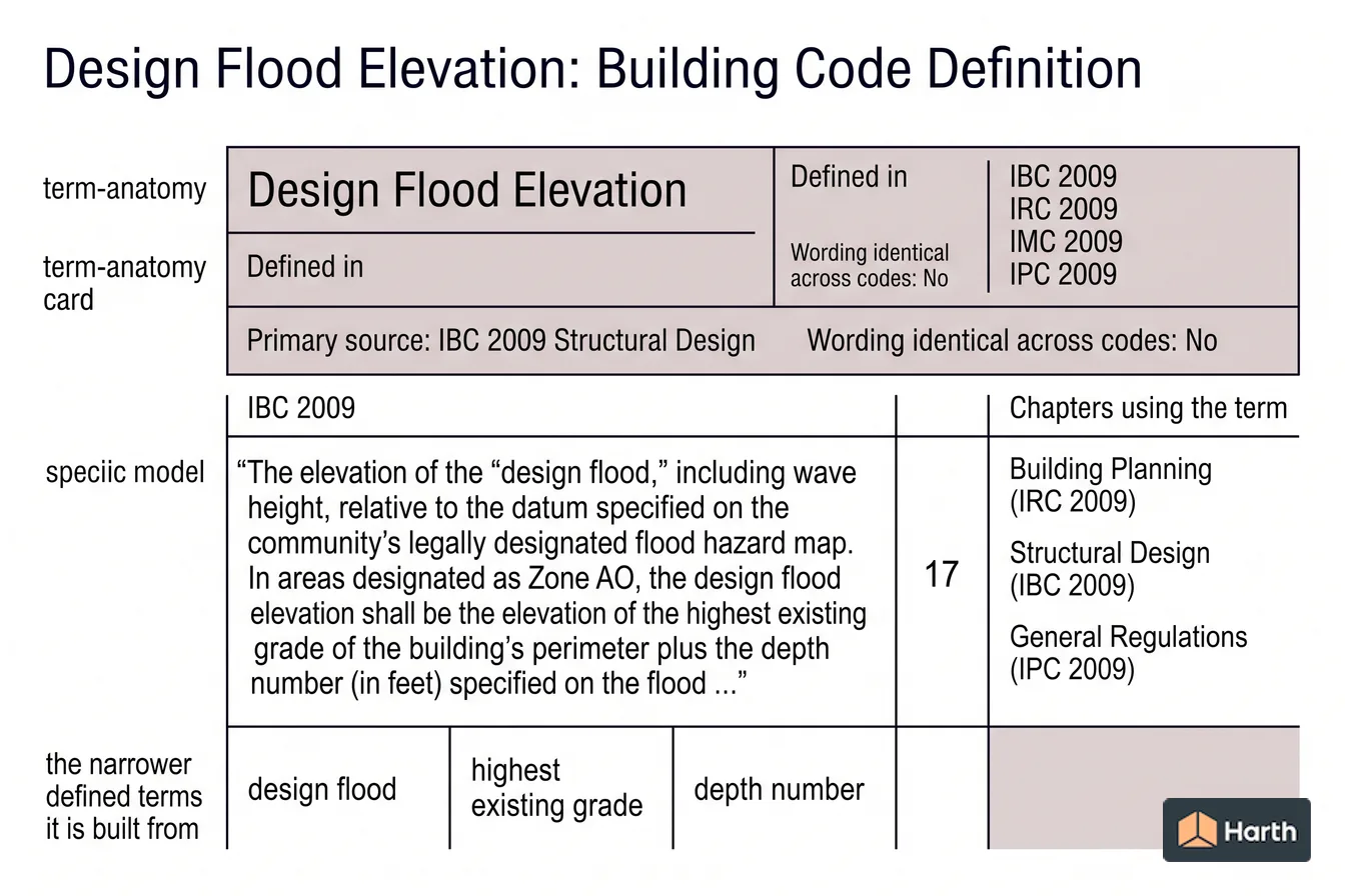
Design flood elevation is a defined term in the International Building Code (IBC) 2009, in Structural Design. The code's own words are: “The elevation of the "design flood," including wave height, relative to the datum specified on the community's legally designated flood hazard map. In areas designated as Zone AO, the design flood elevation shall be the elevation of the highest existing grade of the building's perimeter plus the depth number (in feet) specified on the flood …” The IRC 2009, IMC 2009, IPC 2009 define the same term with different wording, so the controlling text depends on which code governs the question in front of you — the comparison below sets the versions side by side. The term is used in 17 chapters of this corpus, most often in Building Planning (IRC 2009), Structural Design (IBC 2009), General Regulations (IPC 2009). These pages transcribe the 2009 model text; verify the definition against the edition and amendments your authority having jurisdiction has adopted.
Content and cited inputs reviewed by Scott Barrington, Harth founder and architectural technology specialist · Published 2026-09-07 · Updated 2026-09-07.
What does this term mean?
Design Flood Elevation — IBC 2009, Structural Design:
The elevation of the "design flood," including wave height, relative to the datum specified on the community's legally designated flood hazard map. In areas designated as Zone AO, the design flood elevation shall be the elevation of the highest existing grade of the building's perimeter plus the depth number (in feet) specified on the flood hazard map. In areas designated as Zone AO where a depth number is not specified on the map, the depth number shall be taken as being equal to 2 feet (610 mm).
What must be verified before using this guidance?
Four of the I-Codes in this corpus define Design Flood Elevation, and the wording is not identical — read the version that governs your question.
| Code | Where it is defined | Definition |
|---|---|---|
| IBC 2009 | Structural Design | The elevation of the "design flood," including wave height, relative to the datum specified on the community's legally designated flood hazard map. In areas designated as Zone AO, the design flood elevation shall be the elevation of the highest existing grade of the building's perimeter plus the depth number (in feet) specified on the flood hazard map. In areas designated as Zone AO where a depth number is not specified on the map, the depth number shall be taken as being equal to 2 feet (610 mm). |
| IRC 2009 | Fuel Gas | The elevation of the "design flood," including wave height, relative to the datum specified on the community's legally designated flood hazard map. |
| IMC 2009 | Definitions | The elevation of the "design flood," including wave height, relative to the datum specified on the community's legally designated flood hazard area map. |
| IPC 2009 | Definitions | The elevation of the "design flood," including wave height, relative to the datum specified on the community's legally designated flood hazard map. |
Where design flood elevation is used in the code
The term appears in 17 chapters of the 2009 I-Codes hosted here. The chapters that lean on it hardest are the ones to read next.
| Chapter | Code | Mentions |
|---|---|---|
| Building Planning | IRC 2009 | 68 |
| Structural Design | IBC 2009 | 17 |
| General Regulations | IPC 2009 | 11 |
| Scope and Administration | IRC 2009 | 10 |
| Scope and Administration | IBC 2009 | 8 |
| Fuel Gas | IRC 2009 | 6 |
| Accessibility | IBC 2009 | 4 |
| Duct Systems | IMC 2009 | 4 |
| Fuel Oil Piping and Storage | IMC 2009 | 4 |
| General Regulations | IMC 2009 | 3 |
| Soils and Foundations | IBC 2009 | 2 |
| Hydronic Piping | IMC 2009 | 2 |
5 further chapters mention the term.
The term in use
How the code actually writes about design flood elevation, quoted from the 2009 text hosted here:
All structural systems of all buildings and structures shall be designed, connected and anchored to resist flotation, collapse or permanent lateral movement due to structural loads and stresses from flooding equal to the design flood elevation.
In riverine flood hazard areas where design flood elevations are specified but floodways have not been designated, the applicant shall provide a floodway analysis that demonstrates that the proposed work will not increase the design flood elevation more than 1 foot (305 mm) at any point within the jurisdiction of the applicable governing authority.
For structures located in flood hazard areas, the appliance, equipment and system installations regulated by this code shall be located at or above the design flood elevation and shall comply with the flood-resistant construction requirements of Section R322.
The terms design flood elevation is built out of
The definition above leans on 5 other defined terms. Each carries its own code definition, and a local amendment to any of them changes what design flood elevation covers:
- Design Flood — IBC 2009: The flood associated with the greater of the following two areas:
- Building — IBC 2009: Any structure used or intended for supporting or sheltering any use or occupancy.
- Existing — IFC 2009: Buildings, facilities or conditions that are already in existence, constructed or officially authorized prior to the adoption of this code.
- Grade — IRC 2009: The finished ground level adjoining the building at all exterior walls.
- Shall — IRC 2009: The term, when used in the code, is construed as mandatory.
Design Flood Elevation: what to open, and in what order
Every row is a document this term depends on. The ICC code library and the ICC adoption maps cover the middle rows.
| Check | Where | Confirmed |
|---|---|---|
| Read the definition in the adopted IBC | Structural Design | |
| Read the definition in the adopted IRC | Fuel Gas | |
| Read the definition in the adopted IMC | Definitions | |
| Read the definition in the adopted IPC | Definitions | |
| Re-check the requirement that uses it | Building Planning (IRC 2009) | |
| Re-check the requirement that uses it | Structural Design (IBC 2009) | |
| Re-check the requirement that uses it | General Regulations (IPC 2009) | |
| Re-check the requirement that uses it | Scope and Administration (IRC 2009) | |
| Confirm the dependent definition | Design Flood | |
| Confirm the dependent definition | Building | |
| Confirm the dependent definition | Existing | |
| Local amendment to any of the above | Jurisdiction's amendment list |
A research aid, not a code determination. The authority having jurisdiction decides which edition and which amendments apply.
Where can you explore related guidance?
- Explore all glossary guidance
- Design Flood: Building Code Definition
- Existing: Building Code Definition
- Building: Building Code Definition
- Grade: Building Code Definition
Sources and method
Definitions quoted from the 2009 International Codes as transcribed in this site's building-codes collection, with the source chapter linked for each quotation. Usage counts are computed over the chapters hosted here, one copy per code. The ICC code library publishes the current model text and the ICC adoption maps show which edition a jurisdiction has adopted; those sources control.
Source links
Frequently asked questions
What is the code definition of design flood elevation?
The International Building Code (IBC) 2009 defines it in Structural Design as: “The elevation of the "design flood," including wave height, relative to the datum specified on the community's legally designated flood hazard map. In areas designated as Zone AO, the design flood elevation shall be the elevation of the highest existing grade of the building's perimeter plus the depth number (in feet) specified on the flood hazard map. In areas designated as Zone AO where a depth number is not specified on the map, the depth number shall be taken as being equal to 2 feet (610 mm).” The 2009 model text is reproduced here; the definition that binds your project is the one in the edition your jurisdiction has adopted, as amended locally.
Do the I-Codes define design flood elevation the same way?
No. IBC 2009, IRC 2009, IMC 2009, IPC 2009 all define the term, but the wording is not identical, and a difference in wording can change which requirements are triggered. The comparison table above sets the versions side by side so you can read the one that governs your question.
Which parts of the code depend on design flood elevation?
In this corpus the term is used across 17 chapters, led by Building Planning in the IRC 2009. Those are the sections whose scope moves if the definition is amended locally, so read them together with Chapter 2 rather than on their own.
What is the definition of design flood elevation?
In the 2009 I-Codes hosted here it is a defined term rather than a description. The IBC 2009 states, in Structural Design: “The elevation of the "design flood," including wave height, relative to the datum specified on the community's legally designated flood hazard map. In areas designated as Zone AO, the design flood elevation shall be the elevation of the highest existing grade of the building's perimeter plus the depth number (in feet) specified on the flood …” It is defined in IBC 2009, IRC 2009, IMC 2009, IPC 2009. Because it is a defined term, whatever the adopted edition says it means is what every section using it means — so check Chapter 2 of that edition and any local amendment before relying on this wording.
What does base flood elevation 9 mean in Florida?
Base Flood Elevation is a separate defined term. The IBC 2009 defines it as: “The elevation of the base flood, including wave height, relative to the National Geodetic Vertical Datum (NGVD), North American Vertical Datum (NAVD) or other datum specified on the Flood Insurance Rate Map (FIRM).” That is not the same as design flood elevation, which the IBC 2009 defines as “The elevation of the "design flood," including wave height, relative to the datum specified on the community's legally designated flood hazard map. In areas designated as Zone AO, the design flood elevation shall be the elevation of the highest existing …” — read both before applying either, and confirm the wording in the edition your jurisdiction has adopted.
Related pages
- Deluge System: Building Code Definition
Deluge System — IBC 2009 definition: A sprinkler system employing open sprinklers attached to a piping system connected to a water supply …
- Demand: Building Code Definition
Demand — IRC 2009 definition: The maximum amount of gas input required per unit of time, usually expressed in cubic feet …
- Design Earthquake Ground Motion: Building Code Definition
Design Earthquake Ground Motion — IBC 2009 definition: The earthquake ground motion that buildings and structures are specifically proportioned to resist in Section 1613.
- Design Flood: Building Code Definition
Design Flood — IBC 2009 definition: The flood associated with the greater of the following two areas:
- Design Pressure: Building Code Definition
Design Pressure — IFC 2009 definition: The maximum gauge pressure that a pressure vessel, device, component or system is designed to withstand …
- Design Strength: Building Code Definition
Design Strength — IBC 2009 definition: The product of the nominal strength and a resistance factor (or strength reduction factor).